Monday, 28 November 2011
Audio Diary Now Online
During the BORTAS aircraft campaign we made some audio recordings to illustrate what we get up to on fieldwork. I sent these off to the brilliant guys who run the NERC Planet Earth podcast (Sue Nelson and Richard Hollingham) and they have edited them together to create our audio diary. It features in the latest podcast which can be accessed from the Planet Earth Online website at http://planetearth.nerc.ac.uk/multimedia/story.aspx?id=1108. The audio diary comes at the end after a feature about the ozone hole and one about starlings. The audio diary contains interviews with Professor Alastair Lewis from the University of York and the National Centre for Atmospheric Science and Jonny Taylor from the University of Manchester.
Thursday, 8 September 2011
BORTAS paper published in ACPD today!
The first paper from the BORTAS-A measurement campaign was published today in Atmospheric Chemistry and Physics Discussions. Here is a link to the abstract http://www.atmos-chem-phys-discuss.net/11/25099/2011/acpd-11-25099-2011.html and a nice colourful figure from the paper.

Well done to everyone involved in the paper; keep up the good work. I look forward to reading many more BORTAS publications!

Well done to everyone involved in the paper; keep up the good work. I look forward to reading many more BORTAS publications!
Monday, 15 August 2011
Flying is over...now the hard work begins!
As you may have gathered from the last post, all the flight team are now safely back in the UK and the aircraft is getting ready for its next deployment. First impressoins suggest that it was a very successful campaign. We were very lucky with the weather and positioning of the forest fires which meant that we were able to sample ageing plumes on several occassions. It would also seem that we managed to make measurements of plumes at different ages from relatively fresh to several days old. We managed to perform a spiral profile during a satellite overpass, a profile around the time of an ozonesonde launch and two fly-bys of the Pico Mountain Observatory which should allow comparisons with these measurement platforms.

We also got some good publicity and various articles that are available on the net if you want to have a look. It was all kicked off by The Canadian Smoke Newsletter in autumn 2009 which has a section about BORTAS at the end of the autumn 2009 issue (when the aircraft campaign was intended to be in July 2010). Press releases came out just before the start of the campaign in July 2011 from NERC (http://www.nerc.ac.uk/press/releases/2011/19-wildfires.asp) and BAe systems (http://www.baesystems.com/Newsroom/NewsReleases/autoGen_11161311016.html) along with an article in The Herald Scotland. BORTAS also featured in the print versions of the Edinburgh Metro and The Press and Journal - the voice of the North but we couldn't find online versions of those articles. During the campaign in Halifax we had a visit from The Chronicle Herald, a Canadian Newspaper, but I can't seem to get access to the article anymore (headline: Researchers tracking effect of forest fire smoke around the globe), we did make the front page though! Some of our scientists starred on the Global Maritimes evening news, see them at http://www.globalmaritimes.com/video/atmospheric+flights/video.html?v=2079507371&p=1&s=dd#video, and filming took place during one of our flights by the Discovery Channel Canada so we will see what comes from that. The University of York eventually caught up and featured the BORTAS campaign on their news pages on 3rd August. All in all it's good to see that people are interested, now we just have to wait and see what the data shows up!
So now the hard work of analysing, quality assuring and correlating data begins. Updates to the blog will be less frequent but I will keep you up to date with any progress, meetings and (fingers crossed) publication of lots of hard hitting scientific papers.

Clockwise from top left: Aura satellite (from http://aura.gsfc.nasa.gov/), Pico Mountain Observatory, BAe 146 Atmospheric Research Aircraft, ozonesonde launch.
We also got some good publicity and various articles that are available on the net if you want to have a look. It was all kicked off by The Canadian Smoke Newsletter in autumn 2009 which has a section about BORTAS at the end of the autumn 2009 issue (when the aircraft campaign was intended to be in July 2010). Press releases came out just before the start of the campaign in July 2011 from NERC (http://www.nerc.ac.uk/press/releases/2011/19-wildfires.asp) and BAe systems (http://www.baesystems.com/Newsroom/NewsReleases/autoGen_11161311016.html) along with an article in The Herald Scotland. BORTAS also featured in the print versions of the Edinburgh Metro and The Press and Journal - the voice of the North but we couldn't find online versions of those articles. During the campaign in Halifax we had a visit from The Chronicle Herald, a Canadian Newspaper, but I can't seem to get access to the article anymore (headline: Researchers tracking effect of forest fire smoke around the globe), we did make the front page though! Some of our scientists starred on the Global Maritimes evening news, see them at http://www.globalmaritimes.com/video/atmospheric+flights/video.html?v=2079507371&p=1&s=dd#video, and filming took place during one of our flights by the Discovery Channel Canada so we will see what comes from that. The University of York eventually caught up and featured the BORTAS campaign on their news pages on 3rd August. All in all it's good to see that people are interested, now we just have to wait and see what the data shows up!
So now the hard work of analysing, quality assuring and correlating data begins. Updates to the blog will be less frequent but I will keep you up to date with any progress, meetings and (fingers crossed) publication of lots of hard hitting scientific papers.
Tuesday, 9 August 2011
Thunder Bay, Goose Bay, Halifax - a little road trip for the flight crew
So I had to leave the guys in Halifax on 27th but the aircraft didn't leave until 2nd August. The day before I left the aircraft and a slimline crew of scientists (to give as much fuel and space for an engineer) set off to Thunder Bay to try and get some measurements close to the source of the plumes, the fires in Ontario. Since Thunder Bay is a long way from Halifax it was necessary to have an overnight stop there. Plan was to fly straight there, refuel and then fly around the region that had been reported to contain many forest fires. Unfortunately for us there had been a significant amount of rain the day before and many of the fires had been extinguished. I was imagining that there would be amazing pictures of huge fires with black smoke billowing out (probably unlikely they would have got close enough for decent pictures had they still been burning, don't want to dirty all the sensitive instruments), however Steve Andrews did manage to get a picture of some small fires still burning.

The levels of carbon monoxide seen were also less than some of us were expecting so close to the burning source, but we did see our highest levels of methane so far. After a very long day flying the flight crew retired to their hotel, which I have heard was 'less than luxurious', for what in some cases was a disrupted night's sleep. The next day all woke up expecting to be heading back towards Halifax but the weather had other plans. Forecasts for fog and bad weather in Halifax and the surrounding areas meant that the requirements for divert airports could not be met and the aircraft would have to find an alternative place to fly to. Since the plan for the next day was to fly to Goose Bay it was decided to head there for the night and fly out from there in the morning. Let's hope they all took a sufficient supply of clean underwear for their little road/air trip. Despite the bad weather forecast for further east, it was a beautiful morning in Thunder Bay and the aircraft took off and headed to Goose Bay.


The levels of carbon monoxide seen were also less than some of us were expecting so close to the burning source, but we did see our highest levels of methane so far. After a very long day flying the flight crew retired to their hotel, which I have heard was 'less than luxurious', for what in some cases was a disrupted night's sleep. The next day all woke up expecting to be heading back towards Halifax but the weather had other plans. Forecasts for fog and bad weather in Halifax and the surrounding areas meant that the requirements for divert airports could not be met and the aircraft would have to find an alternative place to fly to. Since the plan for the next day was to fly to Goose Bay it was decided to head there for the night and fly out from there in the morning. Let's hope they all took a sufficient supply of clean underwear for their little road/air trip. Despite the bad weather forecast for further east, it was a beautiful morning in Thunder Bay and the aircraft took off and headed to Goose Bay.

Morning at Thunder Bay airport
After an overnight in Goose Bay another long day was planned with a 4 hr instrument warm up then a flight around the Goose Bay area, a refuel and a transit back to Halifax (at last!). During this flight the aircraft instruments saw evidence of aged plumes from forest fires against a clean background of marine air. They performed a vertical profile up to 24,000 ft in the same area as the Goose Bay ozone sonde launch site approximately 30 minutes before the daily sonde was launched which should hopefully give a nice comparison. After flying into and out of the plume numerous times and at several heights the aircraft refuelled at Goose Bay and the tired scientists and crew headed for home (well, the holiday inn/hilton hotels) for a good night's sleep. After all, the next day would be a no flying, hard down day, supposedly for rest and relaxation, but in this case would see the second BORTAS football match and hopefully a win for the flight team this time!
Wednesday, 27 July 2011
Confessions of a model monkey on his first reality tour: part 1

It was only when the FAAM BAe146 aircraft taxied into Halifax airport at the start of BORTAS I suddenly realised how real this experiment was. What had I got myself into?! Sure, I was reasonably prepared but as a model monkey (cf: lab monkey) I usually get to hang around computers and whiteboards and only use data other people collect from their instruments. Here I was with the responsibility to direct this multi-million pound mobile atmospheric laboratory towards fires that are difficult to predict and their resulting pollutant plumes that are, at best, elusive because of their thin layered structure. No plumes to intercept would have serious implications for a number of PhDs and postdoc careers. No pressure, then.
By the time the plane finally stopped and opened its doors, most of the science team were milling around with their bright yellow hi-visibility vests and their identification badges around their necks eagerly waiting to chat with the team that ran instruments on the transit from the UK to Halifax, and to check on their own instruments. I boarded the plane and asked around to see whether the team had intercepted any plumes as they travelled across the Atlantic. Good news, they had seen plumes broadly where the computer model predicted they would be. So far so good.
Tuesday, 26 July 2011
Good Views, But Not The Most Exciting Flight
On Sunday we stayed fairly local and flew out over Prince Edward Island and did some spirals around the area. The reason for this flight was that the Aura satellite (http://aura.gsfc.nasa.gov/) was doing a special overpass of the area. So we flew out over the ocean and since the sky was really clear did a spiral ascent and descent from 25,000 ft to 5,000 ft. From this we should have got some good data to compare with the satellite measurements. There were beautiful views of the island including one showing the clouds confined to the area above the land with totally clear skies over the sea.


We saw traces of a plume but whether it was from biomass burning or some other emissions we are not certain yet; concentrations of the typical tracers, acetonitrile, HCN, were not particularly high. After the flight we had a campaign photo taken, getting everyone together and organised was not an easy job and took a number of people quite some time. But when we got there the guy we asked to take the photo turned out to be a real David Bailey shooting from different directions, angles, even with diferent cameras...still not sure he got a good one...maybe I'll post one later on when I get the files.
Monday was a down day (no flying) with power to the aircraft so there was a small group of us on the aircraft making sure our instuments were working exactly as we wanted. We also had to change some gas cylinders as the plan for today and Wednesday was to fly to Thunder Bay, a double flight (8-10hrs) then stay overnight there and do more flying the next day. This meant that half empty gas cylinders would not last the duration.


Today was an early start with power on the aircraft at 5.30am. Towards the end of the warm up time the arrival of a camera man from the Discovery Channel Canada sparked a flurry of activity mounting a time lapse camera at the back of the aircraft and teaching James Lee to operate a camera for during today's flight. Shalini Punjabi, Guy Gratton and Paul Palmer were also interviewed. More filming will take place on landing tomorrow so keep your eye out for some BORTAS scientists starring on the small screen.


We saw traces of a plume but whether it was from biomass burning or some other emissions we are not certain yet; concentrations of the typical tracers, acetonitrile, HCN, were not particularly high. After the flight we had a campaign photo taken, getting everyone together and organised was not an easy job and took a number of people quite some time. But when we got there the guy we asked to take the photo turned out to be a real David Bailey shooting from different directions, angles, even with diferent cameras...still not sure he got a good one...maybe I'll post one later on when I get the files.
Monday was a down day (no flying) with power to the aircraft so there was a small group of us on the aircraft making sure our instuments were working exactly as we wanted. We also had to change some gas cylinders as the plan for today and Wednesday was to fly to Thunder Bay, a double flight (8-10hrs) then stay overnight there and do more flying the next day. This meant that half empty gas cylinders would not last the duration.

Steve and Steph pose in laser goggles while Eleonora and I check the laser aligniment on the LIF
We have a full on sock monkey epidemic (if you don't know what I'm talking about this might help) here at the airport. It all started with the colourful fella in the picture below who has been posing around the aircraft. Then the discovery of a sock monkey shop in Halifax saw another one materialise (any chance of a photo Mike?). Another scientist has requested the ingredients from the aforementioned shop to enable him to create a masterpiece to take home for his girlfriend and a mascot for the aircraft has also been suggested.

Today was an early start with power on the aircraft at 5.30am. Towards the end of the warm up time the arrival of a camera man from the Discovery Channel Canada sparked a flurry of activity mounting a time lapse camera at the back of the aircraft and teaching James Lee to operate a camera for during today's flight. Shalini Punjabi, Guy Gratton and Paul Palmer were also interviewed. More filming will take place on landing tomorrow so keep your eye out for some BORTAS scientists starring on the small screen.

Filming the pre-flight briefing
Saturday, 23 July 2011
Sharks With Lasers
And another update from the ground team, but this time about more social happenings.......
Post written by Keith Tereszchuk
Well I guess card sharks with LIDARS would be more accurate to describe the attendees of the very first event of the DGS Poker Tour. Last Tuesday night saw some heated Texas Hold'em action at the Duck household as Tom was gracious enough to provide the venue for the inaugural event. The evening saw yours truly up against some hard-nosed DGS rounders in a high stakes, 5¢/10¢ no-limit cash game with minimum $10 buy-in. Tom established his table image early with his TAG (tight aggressive) style of play and took advantage of a hot run of cards to quickly become the chip leader at the table. From there, he continued to bully and intimidate the table by constructing a formidable stack monster.

Tom proudly posing with his stack monster.
It was at this point that the game started to loosen up as 9-year old Thomas returned home from soccer to find that his kitchen table was the sight of an old-fashioned brick and mortar cash game. Tom tried to dissuade his son from wanting to play by telling him that we were playing for real money, only to have Thomas immediately dash up the stairs to his room; and after a couple minutes of rummaging, returned to the table to present his father a huge handful of coins to pay for his buy-in. Young Thomas was now set to endure his first trial by fire at the poker table.

Tom offering young Thomas some sage advice before playing his first hand. Luiza looking upon her husband with a “I pray that Family and Children Services doesn't find out about this...” kinda look on here face.
Thomas played quite well for his first time and his father's tutelage shone through. In fact, it was only after his second or third hand that Thomas picked up some pocket aces and went heads up with James (seen in the red shirt above) and raked in a huge pot such that he could make a stack monster of his own.

Stack monsters abound.
Sadly though, his good fortune did not last very long and it was his own father that felted the lad with an obvious smug grin of delight and satisfaction. Unfazed and defiant, Thomas assured us that he would return to play with us next week for some more high-stakes action, ...right after he asks his dad for a raise in allowance.
Update from the Guys at DGS
Post written by Kaja Rotermund
Here at the DGS (Dalhousie Ground Station), our daily activities aren’t quite as adventurous as those for the Atmospheric Research Aircraft (ARA) and its flight crew, but we still have some exciting news to share. The most interesting of which is the data we were able to collect over the last few days (July17 – July21). We were anticipating the arrival of boreal biomass plumes, but IASI Satellite images for the evening of July 20th indicated that it was possible the plumes would bypass us to the north completely. We were therefore pleasantly surprised and excited when the satellite images of the following morning showed a shift in direction of the plume, bringing it over Halifax. We got even more excited when our lidar plots showed high levels of backscatter congruent with dense plumes. We observed the plume to be below 2km altitude and it stayed overhead for just about a full day. Due to the low altitude, we are very hopeful that the other instruments at DGS were also able to collect data for this event. When looking at the sky from Halifax at this time, a slight haze was definitely visible, which we are convinced must have been the extremely low aerosol plume.
The lidar recorded two sections in the plume. The first plume, which arrived shortly before midnight on the 20th was so dense that water vapor condensed onto the aerosol, forming a cloud. The aerosol is still visible along the outer edges of the cloud though. After a slight break in aerosol density at around 0800UTC, a second plume equally as dense, but with no cloud formation arrived. Unfortunately heavy clouds and fog rolled in after that making it necessary to shut down. Nevertheless, we are still very happy with the measurements we took and are looking forward to comparing our data with those of the other instruments on both the ground station and from the ARA.
Friday, 22 July 2011
Instrument Problems but Another Good Flight
Thursday 21st July, flight B624, and again we were chasing the smoke. This was Axel's last flight as flight manager and so he was aiming for the perfect score for flight quality in the debrief meeting. So far he has been given a 6.5, 7.5 and an 8 out of 10, a bit harsh considering they had a brilliant flight on Wednesday, but maybe it's because they had a power cut at Quebec. So we were aiming for the perfect 10, that elusive perfect flight.
That morning we had a visit from a journalist and a photographer from The Chronicle Herald who chatted to Paul for a while about what we were doing and took some pictures around the aircraft. This was then published on Friday morning on the online site at http://thechronicleherald.ca/NovaScotia/1254489.html.

We took off just before 2pm local time a little early to give us more time for science. Pretty soon after take off, about 20 minutes or so it started to become apparent that this wouldn't be a perfect flight for me! The apparent NO2 concentration shot up but without a corresponding rise in the other channels, a clear indicator that something was wrong. I found a work around and carried on measuring but then about an hour and a half in, another channel, measuring the peroxyacyl nitrates (PANs), also went crazy. On inspection of the tubing connecting our heated inlet to the detection cells I discovered that the one to the PAN cell was full of condensation. Not good news! In the end the decision had to be made to disconnect the inlet and try to dry out the cells by flowing cabin air through. So the measurements made by our LIF instrument score about a 2/10 for this flight.
Thankfully other instruments were behaving better with some interesting shapes being seen in the carbon monoxide (CO) and ozone traces. It looked like we were seeing a really clear boundary between in plume measurements and those around the outside with ozone and CO often anti correlated and the high ozone correlated with nitrogen oxides. The step changes up and down as we flew into and out of the plume were quite striking so hopefully some good science there, just a shame we don't have the reactive nitrogen measurements from the LIF to back it up.
We had some problems with the ground power unit on landing at St John's for a refuel but on the fifth try we managed to get a unit that worked. Then after a short break and some refreshments we headed off again for a short flight back to Halifax. We encountered a plume as we flew out of St John's and another just before landing at Halifax. Debrief was done inflight and after some deliberation the flight was awarded a score of 9.5/10, much to the delight of Axel. Only the lack of LIF measurements lowered the score from the 10 we were hoping for, it was decided that since this was out of my control this must be the pilot's or mission scientist's fault for flying through such damp air. As we landed the rain was hammering down and there was a watefall pouring off the roof of the building. A bit of a damp ending but all in all, a good flight and hopefully sone good data.
That morning we had a visit from a journalist and a photographer from The Chronicle Herald who chatted to Paul for a while about what we were doing and took some pictures around the aircraft. This was then published on Friday morning on the online site at http://thechronicleherald.ca/NovaScotia/1254489.html.
Photograph from the piece on The Chronicle Herald website. Mike working hard on the CIMS instrument.
We took off just before 2pm local time a little early to give us more time for science. Pretty soon after take off, about 20 minutes or so it started to become apparent that this wouldn't be a perfect flight for me! The apparent NO2 concentration shot up but without a corresponding rise in the other channels, a clear indicator that something was wrong. I found a work around and carried on measuring but then about an hour and a half in, another channel, measuring the peroxyacyl nitrates (PANs), also went crazy. On inspection of the tubing connecting our heated inlet to the detection cells I discovered that the one to the PAN cell was full of condensation. Not good news! In the end the decision had to be made to disconnect the inlet and try to dry out the cells by flowing cabin air through. So the measurements made by our LIF instrument score about a 2/10 for this flight.
Thankfully other instruments were behaving better with some interesting shapes being seen in the carbon monoxide (CO) and ozone traces. It looked like we were seeing a really clear boundary between in plume measurements and those around the outside with ozone and CO often anti correlated and the high ozone correlated with nitrogen oxides. The step changes up and down as we flew into and out of the plume were quite striking so hopefully some good science there, just a shame we don't have the reactive nitrogen measurements from the LIF to back it up.
We had some problems with the ground power unit on landing at St John's for a refuel but on the fifth try we managed to get a unit that worked. Then after a short break and some refreshments we headed off again for a short flight back to Halifax. We encountered a plume as we flew out of St John's and another just before landing at Halifax. Debrief was done inflight and after some deliberation the flight was awarded a score of 9.5/10, much to the delight of Axel. Only the lack of LIF measurements lowered the score from the 10 we were hoping for, it was decided that since this was out of my control this must be the pilot's or mission scientist's fault for flying through such damp air. As we landed the rain was hammering down and there was a watefall pouring off the roof of the building. A bit of a damp ending but all in all, a good flight and hopefully sone good data.
Thursday, 21 July 2011
Highest CO yet and smoke in the cabin!
Post by Andrew Rickard
Today the ARA flew two flights (B622 and B623) with a refuel in Quebec in order to intercept some intense plumes forcast nearer to the fire area of interest. B622 was flown as planned to the west then back into Quebec in excellent flying conditions. There was substantial evidence of biomass burning in discrete layers around 13-15,000 ft. Discrete thin layers of brown haze were clearly observable (picture to follow). We observed CO up to 1 ppmv in one layer, a new record! The Manchester CIMS and UEA PTRMS were also observing high levels of acetonitrile, a fairly unique tracer of biomass burning. At one point a distinct faint smell of woodsmoke was discernible within the cabin!
Between flights, the ground power to the aircraft in Quebec failed, and for a while it looked like we might have to cancel the second leg. However, with all hands to the pump and some quick thinking by the onboard scientists, disaster was avoided and the majority of the instruments were quickly back up and running close to normal, delaying departure by only 30 minutes. B623 original flight plan was altered owing to weather, returning (via US airspace to avoid a line of storm clouds and lightning strikes) to the Halifax area, with profile runs NW of Halifax in order to capture the extent of the biomass burning (BB) plume area. We then recieved some very interesting data from the Dalhousie LIDAR in downtown Halifax of an intense BB plume directly over Halifax itself. We quickly decided this was an opportunity not to be missed and so the quick thinking pilots performed spiral ascents and descents above Halifax up to 25,000ft in conjunction with Dalhousie Lidar (quite interesting for those onboard!). Both flights were highly successful and will deliver a multitude of science. It is credit to the enthusiasm and professionalism of both the full team on board G-LUXE (the code for the aircraft), and of the local Air Traffic Control Services in delivering a very high quality sortie despite substantial adverse factors.
Wednesday, 20 July 2011
Trip to Quebec
So the aircraft went to Quebec today and actually as I am writing this we are waiting for confirmation that they have refuelled successfully and have taken off again. The aircraft took off from Halifax at 12:00 pm local time and Guy Gratton managed to get a picture of it.
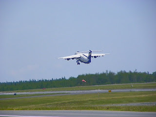


The BAe146 taking off
From Halifax they headed north west and then turned more westerly. They saw some strong indications that they were sampling air from a plume beleived to have originated over the fires in Ontario. Carbon monoxide was even higher than on Monday and other biomass burning tracers were measured. They also saw some short lived reactive compounds at 20,000 ft which is very interesting. After transitioning in and out of the plume for a long time and over quite a large spatial area they landed in Quebec to refuel.
And we just have news that they are airbourne again, but there are forecasts of lightning so they will have to keep an eye out for that. Tom Duck at Dalhousie University is seeing some aerosol at low altitudes from his lidar (~2 and 4.5 km altitude) which agrees well with Mark's predictions.

On the far right hand side you can see a light blue/green layer at 2km and a red layer coming in at 4-5km. These are aerosol layers that may indicate that they are seeing a biomass burning plume at Dalhousie. Follow the plot updating at http://aolab.phys.dal.ca/data/current/
Latest news says that the route of the aircraft has had to be changed because of the lightning and bad weather so hopefully there won't be any serious delays and they will still see some exciting stuff. Keep track of where we are up to at http://faam.badc.rl.ac.uk/public/gluxe_position/satmap.html

Lightning strikes across the area we are flying in.
Tuesday, 19 July 2011
Chasing Plumes from Fires in North Western Ontario
In order to fit two flights into the day we had to have a fairly early start so power was on at 7am with take off at 11am local time. After take off we set off in a north easterly direction from Halifax, heading for Stevenville at 25,000 ft. Before long we started to see some structure in the carbon monoxide (CO) indicating that we might be seeing some pollution. Dave who operates the proton transfer mass spectrometer (PTR-MS) reported he was starting to see some acetonitrile, a tracer for biomass burning, and the LIF saw increased levels of PAN. The core chemistry operators, Seb and Steph, reported that the methane seemed to show a correlation with the carbon monoxide, as did the HCN trace (another indicator for biomass burning) from the CIMS instrument. This news was very welcome showing that all indicators were suggesting we were in the plume we were hoping for.
The original plan had been to drop down to a lower altitude for the next run but since there was a cloud layer below us it was decided that we would stay at 25,000 ft and fly back through part of the plume. Here we saw the highest concentrations that we had seen so far and in fact the carbon monoxide concentrations shot up to the highest value that Steph has ever seen on the aircraft except when we are sampling next to the generator at the airport. Data analysis and investigation post flight will tell us if this is real but it is definitely exciting stuff. As we turned to head NNW we descended to 5000 ft at 1500 ft/min but once we were down there nothing was really happening so after a short run we ascended again to 25,000 ft for our approach to Goose Bay. Unfortunately on this run we saw very little action.
The weather at Goose Bay was not good; it was both wet and windy and there were little rivers on the runway. We did however see a very interesting aircraft. It was a CL215 Snooper which is an amphibious firefighting aircraft. Apparently it scoops up water from the surface of the sea or lakes and then squirts it out over fires. Very cool!

We took off from Goose Bay around 16:30 and headed NW. There wasn't much to see where we had expected to find the plume so we tried different headings and altitudes but we just couldn't locate our plume. The guys on the ground, particularly Mark Parrington were brilliant. They sent us satellite images, predicted altitudes of carbon monoxide along our intended track and pretty much anything else we asked for. Towards the end of the flight Dave on the PTR-MS reported that although he wasn't seeing any biomass burning tracers he was seeing high concentrations of some interesting compounds including terpenes. This was confirmed by the GC-MS measurements and also some elevated CO. After this dropped off, on our approach to Halifax we started to see indications that we were getting back into a biomass burning plume. This had not been predicted by the models or indicated by the satellite measurements so again, an interesting find, just unfortunate it happened as we were running out of fuel and crew hours and so couldn't investigate it further. We landed in Halifax just before 10pm, a long day but hopefully some good science will come out of it.
The original plan had been to drop down to a lower altitude for the next run but since there was a cloud layer below us it was decided that we would stay at 25,000 ft and fly back through part of the plume. Here we saw the highest concentrations that we had seen so far and in fact the carbon monoxide concentrations shot up to the highest value that Steph has ever seen on the aircraft except when we are sampling next to the generator at the airport. Data analysis and investigation post flight will tell us if this is real but it is definitely exciting stuff. As we turned to head NNW we descended to 5000 ft at 1500 ft/min but once we were down there nothing was really happening so after a short run we ascended again to 25,000 ft for our approach to Goose Bay. Unfortunately on this run we saw very little action.
The weather at Goose Bay was not good; it was both wet and windy and there were little rivers on the runway. We did however see a very interesting aircraft. It was a CL215 Snooper which is an amphibious firefighting aircraft. Apparently it scoops up water from the surface of the sea or lakes and then squirts it out over fires. Very cool!

Picture taken at Goose Bay of the CL215 aircraft
We took off from Goose Bay around 16:30 and headed NW. There wasn't much to see where we had expected to find the plume so we tried different headings and altitudes but we just couldn't locate our plume. The guys on the ground, particularly Mark Parrington were brilliant. They sent us satellite images, predicted altitudes of carbon monoxide along our intended track and pretty much anything else we asked for. Towards the end of the flight Dave on the PTR-MS reported that although he wasn't seeing any biomass burning tracers he was seeing high concentrations of some interesting compounds including terpenes. This was confirmed by the GC-MS measurements and also some elevated CO. After this dropped off, on our approach to Halifax we started to see indications that we were getting back into a biomass burning plume. This had not been predicted by the models or indicated by the satellite measurements so again, an interesting find, just unfortunate it happened as we were running out of fuel and crew hours and so couldn't investigate it further. We landed in Halifax just before 10pm, a long day but hopefully some good science will come out of it.
Sunday, 17 July 2011
Picture of BAe146 Atmospheric Research Aircraft
Steve Andrews took a brilliant picture of the aircraft the other day. I think it looks really impressive!


Day out in Halifax and Plan for Tomorrow
So yesterday was a 'soft down day' which means there was power to the aircraft for instrument maintainance but no flying. So while some of the scientists spent the day trying to fix their instruments, others of us had a couple of meetings then went out into Halifax. We parked down by the waterfront and wandered down to the jazz festival area. After a look around, some lunch and some brilliant raspberry wheat beer we headed further along the waterfront where we saw an rather intruiging selection of ice cream flavours on offer, shame we had just had lunch. What would Tiger or Bear Paws ice cream taste like? Answers on a post card, or probably easier as comments below.

Next stop was the Citadel, and we were lucky to be there on a special day (Doug was told the centenary of National Parks or something like that) so we were able to get in for free. As we walked up the hill we saw what looked like a large ship behind a grassy bank. We were then stopped out side the gate leading through the grass bank to watch the changing of the guard.


We walked around the inside of the grass banks which afforded a great view of Halifax and of the ceremony going on inside the castle. You would almost believe you were actually in Scotland, with kilts, bagpipes and even a huge union jack.

We then went back down into the town to look around the local bars and eateries. Andrew Rickard found some nachos which looked just too good (and big) not to sample, evidence below.

So onto some science (sort of); the plan for tomorrow is to take off around 11am (meaning power to instruments is at 7am) and head towards Goose Bay, Newfoundland where we will hopefully intercept a plume from the fires currently burning in North West Ontario (see the map produced by Natural Resources Canada). We can then refuel there, allowing us to fly a bit longer, before heading back to Halifax late on in the evening. This will give us about 9 hours flying so we would expect to get some good data. Only things to watch out for is interference from North American pollution, clouds and rain, and the potential for thunderstorms around Halifax later on in the day. Fingers crossed we will see something exciting!
Saturday, 16 July 2011
Landing at Horta in the Azores
This video footage was taken by Prof. Ally Lewis on the transit flight when the BAe146 Atmospheric Research Aircraft landed at Horta. Take a look at the runway, it is quite unusual. In discussions it was compared to an aircraft carrier since it is short and has ocean at both ends. As usual though, it was a smooth and uneventful landing from our excellent pilots. The video is also up on our facebook page and is probably better quality there.


Ally also took some great pictures around the Pico Mountain Observatory (although you can't actually see it) as they flew by for the intercomparison (see post from 21st April 2011).


Friday, 15 July 2011
First Science Flight Out of Halifax
So the flight today was not particularly successful. With the exception of a few bumps in the CO concentration, the odd fluctuation in the amount of peroxyacetyl nitrate (PAN), a little acetonitrile and a trace of black carbon there really wasn't a lot of evidence of the plume we were hoping to see. Part of the problem was that we couldn't get permission to fly as low as we wanted to so we had to stay above 13,000 ft. Out the window we saw lots of trees, some hills and a white water river sparking comments from the pilots comparing Nova Scotia to the original Scotland. Probably the most exciting bit was some slight turbulence as we flew through the top of the cloud. There were some indications that there was uplift through the cloud from the boundary layer below; the PTR-MS saw some isoprene, a compound most commonly emitted by vegitation, and MVK, a product of the breakdown of isoprene. It looked like the level of PAN also went down then which would support this suggestion since PAN is a reservoir compound for nitrogen oxides which degrades at the higher temperatures found lower in the atmosphere.
Despite the lack of scientific excitement Axel Wellpot, the flight manager, was still very busy as can be seen by the number of windows he has open on his three screens! He has to keep a record of changes in flight level, control a number of core instruments, print predictions of pollution for the mission scientist and weather for the
pilots, he produces beautiful Google Earth plots for data visualisation and does numerous other things I don't even know about.

The scientists were showing less dedication to the cause as evidenced by the pictures below, but then there wasn't much else to do except watch your instrument flatline for 4hrs. Maybe in post processing we can see something of more use in the finer detail of the measurements but none of the massive elevations in concentration we were hoping for.


There are still a couple of instrument issues; the GC-MS pump continues to leak so the GC-MS now has to share the pump that is used to fill the whole air sampling (WAS) bottles, the NOx analyser has flow rate problems at high altitude (above about 20000 ft) and it looks as though the instrument that measures CO2
and methane was sucking a small amount of air in from the cabin. Stephane Bauguitte, the core chemistry operator, thinks that is now fixed but ideally he would put in a new, dedicated inlet for that instrument to ensure that sufficient flow is maintained and so it will not suck in any cabin air. Watch this space to find out if we can fix any of these problems or if we will just have to find a way to work around them.

In other news we saw a rather interesting looking aircraft outside the hanger we are working at yesterday. Looks to me like the propellers are on backwards but the engineers, after a little joking around, assured me that it makes no difference and that it is just the way the Japanese decided to build that particular model.

Despite the lack of scientific excitement Axel Wellpot, the flight manager, was still very busy as can be seen by the number of windows he has open on his three screens! He has to keep a record of changes in flight level, control a number of core instruments, print predictions of pollution for the mission scientist and weather for the
pilots, he produces beautiful Google Earth plots for data visualisation and does numerous other things I don't even know about.


and methane was sucking a small amount of air in from the cabin. Stephane Bauguitte, the core chemistry operator, thinks that is now fixed but ideally he would put in a new, dedicated inlet for that instrument to ensure that sufficient flow is maintained and so it will not suck in any cabin air. Watch this space to find out if we can fix any of these problems or if we will just have to find a way to work around them.

Steph and Seb try and fix the problem with the CO2 instrument while Piero talks to Axel.
In other news we saw a rather interesting looking aircraft outside the hanger we are working at yesterday. Looks to me like the propellers are on backwards but the engineers, after a little joking around, assured me that it makes no difference and that it is just the way the Japanese decided to build that particular model.

Wednesday, 13 July 2011
Update on Progress and Sources of Information
So the BAe146 ARA took off from Cranfield, UK yesterday and travelled down to Horta in the Azores where it stayed overnight. This morning it took off again to fly first to St John's and after a quick refuel, to Halifax, Nova Scotia. Early reports sent from Professor Ally Lewis who is mission scientist for the transit flight suggest that all instruments being operated on the transit are working well with a few minor issues at high altitude. Inflight data seemed to follow the predictions made by Mark Parrington's GEOS-5 CO forecasts remarkably well. The aircraft is due to land in Halifax around 1800Z or 1500 local time.
Andrew Elford uploaded a picture of the first ozonesonde launch for the BORTAS-B campaign to the BORTAS facebook group yesterday and it is also shown below. Hopefully we will have some other updates from the ground team soon as they have been working hard for the last few weeks getting everything running and collecting data in the run up to the aircraft campaign.

If you are interested in the data that is being collected there are a few online resources you might be interested in. Information about and data from the ozonesonde launches can be found at http://exp-studies.tor.ec.gc.ca/~bortas/. On this site there is a table containing the dates of launches and under each location links to a data file (labelled D) and a graph (labelled G) so that you can see what the vertical profile of temperature and ozone concentration look like. The Atmospheric Optics Laboratory at the University of Dalhousie has a webpage which links data from the Dalhousie ground station and has recent plots from the lidar, this can be found at http://aolab.phys.dal.ca/data/archive/halifax_2011/. They also have a page that will display live plots from the lidar at Dalhousie and that is located at http://aolab.phys.dal.ca/data/current/. If you want to see where the aircraft is when it is airborne this webpage http://faam.badc.rl.ac.uk/public/gluxe_position/satmap.html shows its current position and also the track it has taken during that particular flight. The GEOS-5 CO forecasts are updated daily at http://www.geos.ed.ac.uk/research/eochem/bortas/coforecast.html and the number of forest fires is displayed by the University of Maryland's web fire mapper at http://firefly.geog.umd.edu/firemap/. Of course you can also follow updates on twitter or facebook and keep visiting the blog for news, pictures and more information.
Andrew Elford uploaded a picture of the first ozonesonde launch for the BORTAS-B campaign to the BORTAS facebook group yesterday and it is also shown below. Hopefully we will have some other updates from the ground team soon as they have been working hard for the last few weeks getting everything running and collecting data in the run up to the aircraft campaign.

The first ozonesonde launch of the BORTAS-B campaign which took place at Egbert yesterday.
If you are interested in the data that is being collected there are a few online resources you might be interested in. Information about and data from the ozonesonde launches can be found at http://exp-studies.tor.ec.gc.ca/~bortas/. On this site there is a table containing the dates of launches and under each location links to a data file (labelled D) and a graph (labelled G) so that you can see what the vertical profile of temperature and ozone concentration look like. The Atmospheric Optics Laboratory at the University of Dalhousie has a webpage which links data from the Dalhousie ground station and has recent plots from the lidar, this can be found at http://aolab.phys.dal.ca/data/archive/halifax_2011/. They also have a page that will display live plots from the lidar at Dalhousie and that is located at http://aolab.phys.dal.ca/data/current/. If you want to see where the aircraft is when it is airborne this webpage http://faam.badc.rl.ac.uk/public/gluxe_position/satmap.html shows its current position and also the track it has taken during that particular flight. The GEOS-5 CO forecasts are updated daily at http://www.geos.ed.ac.uk/research/eochem/bortas/coforecast.html and the number of forest fires is displayed by the University of Maryland's web fire mapper at http://firefly.geog.umd.edu/firemap/. Of course you can also follow updates on twitter or facebook and keep visiting the blog for news, pictures and more information.
Wednesday, 29 June 2011
Comparison of GEOS-5 CO Forecasts with Satellite Measurements
At the science team meeting Mark Parrington from the University of Edinburgh presented an analysis of the GEOS-5 CO forecasts with satellite measurements during the BORTAS-A campaign last summer. His analysis showed that the predicted locations of elevated concentrations generally compared well with measurements but that the levels of CO were often overestimated.


So what we see is that the model seems to reproduce the locations where CO levels will be elevated but that it consistently shows a bias predicting much higher CO levels than those observed. This is not terrible news since our use of the forecasts is to enable us to be in the right place to observe the biomass burning plumes, characterised by high CO. It looks like the forecasts will be able to tell us where to go, just that we shouldn't expect to see concentrations that are quite as high as the model suggests.

On the left is the CO predicted by GEOS-5 using the IASI averaging kernels. On the right is the CO retrieved from the IASI satellite measurements.
It can be seen from the above plots that the levels of CO are overestimated by the GEOS-5 prediction relative to the IASI measurments and that the geographical spread of the elevated concentrations appears to be too great. By plotting the difference between the modelled and measured data we can see more clearly that the model predicts too much CO in most ares (see plots below).

The percentage difference was plotted for measurements made when cloud cover was less than 12% and less than 5% to see if the lower values in the IASI CO measurements were due to cloud or aerosol in the pixels used for the calculation. The plots above show that the modelled values are still significantly higher when less cloud is present. The average bias towards higher values remains constant for different levels of cloud cover as the plot below demonstrates. This shows the probability distribution of the difference between the predicted and measured CO. The average difference is 10 % for both cloud conditions considered (less than 5% and less than 13%) and for all data and boreal only data.

Plot showing the percentage difference between modelled and measured CO for satellite measurements reporting less than 12% cloud cover on the left and less than 5% on the right.

This shows the probability distribution of the difference between the predicted and measured CO concentrations. The dotted lines show this just for the boreal region (> 50oN) with the red lines showing data with less than 5% cloud cover and the black lines less than 13%.
Thursday, 16 June 2011
Podcast Preparation
So this morning I had a meeting with Richard Hollingham, a journalist and broadcaster who presents the NERC Planet Earth Podcast. During the BORTAS campaign we will be recording an audio diary which, if my recording skills are up to it and my chat is interesting enough, will feature on the aforementioned podcast. There's a good example of the audio diaries they use in the podcast episode entitled "cuckoos at Wicken Fen, snow and radiocarbon dating". The audio diary starts around 9 minutes in.
There will be some challenges associated with recording on the plane, particularly the background noise. The aircraft cabin is pressurised so in theory it should be really quiet inside but with all the pumps that are used to draw air through the various instruments running the noise levels can actually be really high. We'll have to experiment with the best place to hold the microphone and what recording levels work best.
 The audio recorder, cover and windjammer
So now I have in my possession a handheld digital audio recorder with microphone cover and windjammer, and I've been told to have a go at making recordings around the laboratory, outside and anywhere else with interesting noises. So those of you who work at University of York, beware, I might be after you for an interview....and anyone else involved in the campaign - practise being interesting so that we can get some brilliant interviews for the actual audio diary.
There will be some challenges associated with recording on the plane, particularly the background noise. The aircraft cabin is pressurised so in theory it should be really quiet inside but with all the pumps that are used to draw air through the various instruments running the noise levels can actually be really high. We'll have to experiment with the best place to hold the microphone and what recording levels work best.

So now I have in my possession a handheld digital audio recorder with microphone cover and windjammer, and I've been told to have a go at making recordings around the laboratory, outside and anywhere else with interesting noises. So those of you who work at University of York, beware, I might be after you for an interview....and anyone else involved in the campaign - practise being interesting so that we can get some brilliant interviews for the actual audio diary.
Tuesday, 31 May 2011
Ozone Sonde Launches
I have mentioned before on Twitter that we have some brilliant collaborations going on which will help us understand the data we collect during BORTAS this summer. Many of these have already started with scientists from a number of universities and institutes collecting data during the BORTAS-A period last year. In earlier posts I talked about the Pico Mountain Observatory and the lidar at Dalhousie University but another useful and exciting activity that will be going on this summer, and in fact goes on all year round, is the launching of ozone sondes across Canada by the Environment Canada Experimental Studies Unit (ARQX).
The first question might be 'what is an ozone sonde?'....good question. Sonde is the French word for probe and so it makes sense that this is essentially a probe to measure ozone. They are lightweight instruments that can be carried by a helium filled balloon (not a party balloon, these ones are slightly bigger and more robust). The iodide redox reaction (shown below) is used to allow ozone to be detected.


The first question might be 'what is an ozone sonde?'....good question. Sonde is the French word for probe and so it makes sense that this is essentially a probe to measure ozone. They are lightweight instruments that can be carried by a helium filled balloon (not a party balloon, these ones are slightly bigger and more robust). The iodide redox reaction (shown below) is used to allow ozone to be detected.
2KI + O3 + H2O -> I2 + O2 + 2KOH
This reaction is used to produce an electrical signal which is proportional to the ozone concentration. This can be done in a number of ways each of which is explained at http://www.atmosp.physics.utoronto.ca/SPARC/SPARCReport1/1.08_O3sondes/1.08_O3sondes.html. The sonde also includes meteorological instruments to measure pressure, temperature and humidity. The balloon carrying the ozone sonde can travel upwards as far as 35 km before the balloon bursts. This happens because as pressure decreases higher up in the atmosphere the helium inside the balloon expands into the lower pressure surroundings. The balloon can not expand indefinitely and so eventually it bursts.

On the left is the inside of an ozone sonde showing the two solutions used to create the electric current. The other two pictures show ozone sonde launches with the middle one using a special balloon which can get to higher altitudes (it looks very dramatic!).
ARQX launch ozone sondes weekly from ten locations across Canada. During BORTAS they will also launch daily sondes from Yarmouth, Sable Island, Goose Bay, Egbert and Bratt's Lake. There is also the possibility of additional launches if a plume is predicted to pass over one of the launch sites. The sites are all shown on the map below. Ozone sonde launch sites are identified by the symbol that resembles a balloon carrying an object (an ozone sonde of course). Also depicted on this map are sites that operate lidar instruments similar to that operated at Dalhousie University and sites which have Brewer spectrophotometers. These instruments measure total ozone and UV radiation, to find out more have a look at the Environment Canada pages at http://exp-studies.tor.ec.gc.ca/e/ozone/ozone.htm.

Network of ozone sonde launch sites, lidar locations and sites with Brewer spectrophotometers.
David Tarasick from ARQX kindly provided me with some plots from data collected during the BORTAS-A period last year. On numerous occasions the vertical profiles from ozone sonde flights show regions of elevated ozone. An example of this is shown below.

Left hand plot shows the vertical profiles taken by the ozone sonde at Edmonton with ozone mixing ratio in black. The area of high ozone is circled in red. The right hand plot shows where the air at Edmonton had come from overlayed on the fire counts for the previous day.
These plots show that the air sampled is likely to have been impacted by the fires north east of Edmonton and this could be the cause of the elevated ozone. Another example is shown below from the Goose Bay site. This shows not only the data from the ozone sonde but also aerosol measurements from the lidar and the carbon monoxide (CO) forecast carried out by scientists at Edinburgh University. All plots indicate something is happening between 4 and 8 km with CO and ozone mixing ratios and aerosol backscatter ratio and cross section all being elevated.This supports the suggestion that the elevated ozone is a result of biomass burning activity.

The top left plot shows the ozone sonde profiles, top right is the predicted CO from the GEOS-5 model, bottom left is the aerosol backscatter cross section and bottom right is the aerosol backscatter ratio.
From this data we can say that elevated ozone is observed at ozone sonde stations downwind of large boreal forest fires. Back trajectories suggest that the sampled air passed over a region of burning. This elevated ozone may be the result of reactions involving nitrogen oxides, CO and hydrocarbons which are present in biomass burning plumes. The presence of aerosol layers at similar altitudes would support the suggestion that burning plumes have influenced the composition of the air mass. A possibility that can not yet be ruled out is that the elevated ozone is from air that has travelled into the lower atmosphere from the stratosphere where ozone concentrations are significantly higher. This is supported by the relative humidity profiles which show dry air at the altitudes where ozone is elevated but the coincidence of plume interception (suggested by the lidar aerosol data and trajectories) and downwards mixing of stratospheric air is unexplained. Hopefully measurements this summer will add some pieces to this puzzle and help us understand the processes going on in and around aging forest fire plumes.
Thanks to David Tarasick for pictures, data plots and information.
Friday, 27 May 2011
Satellite Measurements of Trace Species
Post written by Keith Tereszchuk.
One of the objectives of BORTAS will be to compare the in-situ aircraft measurements made during the flight campaign with remote sensing data provided by satellites. Space-borne observation is used extensively in many facets of monitoring of the Earth’s surface and atmosphere including weather forecasting, air quality measurements, ozone levels (UV Index), volcano emissions, ocean currents, sea/lake roughness (wave height), desertification assessment and numerous other such environmental management studies. These are just a few examples of the importance of satellite monitoring and how the information they provide us directly impacts our day-to-day lives. The identification and characterization of biomass burning plumes and their effect on atmospheric chemistry is yet another area of study conducted using satellite remote sensing.


One of the objectives of BORTAS will be to compare the in-situ aircraft measurements made during the flight campaign with remote sensing data provided by satellites. Space-borne observation is used extensively in many facets of monitoring of the Earth’s surface and atmosphere including weather forecasting, air quality measurements, ozone levels (UV Index), volcano emissions, ocean currents, sea/lake roughness (wave height), desertification assessment and numerous other such environmental management studies. These are just a few examples of the importance of satellite monitoring and how the information they provide us directly impacts our day-to-day lives. The identification and characterization of biomass burning plumes and their effect on atmospheric chemistry is yet another area of study conducted using satellite remote sensing.

SCISAT-1 with ACE-FTS
BORTAS will be using data from the Atmospheric Chemistry Experiment (ACE) on-board the Canadian satellite SCISAT-1, which uses a high-resolution Fourier transform spectrometer (ACE-FTS) for remote sensing of the limb (see picture) of the Earth's atmosphere down to 3-km above the Earth’s surface (just above the tropospheric boundary layer). The ACE-FTS has wide spectral coverage in the infrared region of the electromagnetic spectrum scanning a contiguous region from 750 to 4400 cm-1 and currently offers data retrievals for 38 molecular species as well as their isotopologues, over a dozen of which are known biomass burning marker species, e.g. CO, HCN, HCOOH, H2CO, C2H6, C2H2, CH3OH, HNO3, CH4.

View of the limb of the Earth at sunset
Unlike nadir instruments, which look directly down towards the surface of the Earth, ACE peers through the limb of the atmosphere recording sequential absorption spectra using the sun as an emission source. Each sunrise and sunset of the satellite is called an occultation and they provide concentration profile information of each molecular species with respect to altitude. Much like ogres and onions, ACE can be used to separate the atmosphere into distinct layers with a spatial resolution of 1 km. On average, 20 measurements are made on a daily basis.

The Atmosphere: It has layers

ACE occultation of the Earth’s Atmosphere
ACE provides widespread global coverage and during the BORTAS campaign, it will make a total of five measurements that will be within the 500 nautical mile range of the FAAM aircraft which will be based in Halifax. These measurements will be used to compliment the data recorded during the aircraft flights to further understand the chemical evolution of molecular species emitted by biomass burning.

Ideally we would like to be able to identify the sources of the plumes that will be measured during the campaign to study molecular evolution within them, and satellites can help us do that too. We will be using data from the MODIS Terra instrument, which is a spectroradiometer that records surface temperatures of the Earth including thermal anomalies such as actively burning fires, to identify potential source regions. When the location of fires are known, we can determine the plume sources by calculating air-mass trajectories using a program called HYSPLIT, which is a Lagrangian particle dispersion/trajectory model based on satellite climatologies. These climatologies provide information on air-mass flow at a particular time at any point in the atmosphere across the entire globe. Using the ACE profiles of the biomass burning marker species, we can determine the altitude that corresponds to the highest concentrations of these molecules and use this altitude as the injection point for backtracking the air-mass flow to its source using HYSPLIT. In addition, we can calculate forward trajectories from identified sources. If these trajectories coincide both spatially and temporally, we can confidently confirm the source of the plume measured.

Positions of the predicted ACE occultations, shown by circular ACE logos. The red circles show the distance from Halifax where the aircraft will be based.

HYSPLIT trajectories. Backtracking from an ACE measurement made over Hudson Bay and four forward trajectories made from known biomass burning events over northern Saskatchewan and the Northwest Territories (July 2008).
Bringing together all the aforementioned information, we will be able to characterize biomass burning plumes to further our understanding of the overall impact of biomass burning on atmospheric chemistry.
Subscribe to:
Posts (Atom)

